|
|
 |
 |
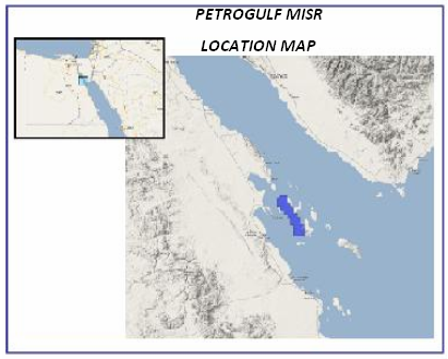
Location
|

|
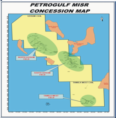
The company's concession is located southeast of the Zeit bay at the offshore southern part of Gulf of Suez, approximately 70 km northwest of Hurghada city and covered an area about 105 Km2. The area is characterized by rapid changes in water depth from (0) to (200) Ft. The water depth is complicated by presence of pinnacle and barrier reefs that surround the island. The concession area Includes Geisum and Tawila West fields.
|
|
|
The primary reservoirs in the South Geisum field consist of the Kareem Sand, Thebes Carbonate, , Matulla, Nubia sand and fractured Basement, whereas the Miocene sand is the primary reservoir in both the North Geisum and Tawila West fields.
|
|
|
Drilling History:- - 1985: Geisum Company is established as a joint venture company between EGPC and Conoco. During the partnership from (1985-1987) the company had successfully drilled four wells in South Geisum field.
- 1987: Conoco assigned its interest in the concession agreement to EGPC, who became the sole owner of Geisum oil company as joint venture company.
- 1988-1990: the company drilled four development wells in South Geisum field. In 1989 discovered oil in the Cretaceous sand and the fractured Granitic basement in the north-eastern side of South Geisum field.
- 1991-1999: the company started the development of Miocene sand in North Geisum field. In 1991, discovered the Basal Rahmi Sand as a new Miocene reservoir unit.
Seventeen wells were successfully drilled, based on the two dimensional seismic interpretation conducted in 1993, and the simulation study carried out in the field in 1993.
- 1994: Geisum was granted Tawila West concession for development and In 1996 Geisum drilled its first well in Tawila field.
- 1999-2005: a successfully development campaign had been performed for South; North Geisum and Tawila fields, based on the interpretation of the 3D seismic conducted in 1998, and the geological studies carried out for the fields.
In 1998, Thebes Carbonate had been added as a new reservoirs in South Geisum field.
- 2007: Geisum oil company was re-named Petrogulf Misr Company after established a joint venture company between Ganope, Pico Gos Petroluem Company Limited and Kufpec (Egypt) Limited.
The company achieved the development plan, by drilling one well in Tawila field, followed by ten wells in South Geisum and two wells in North Geisum whereas all wells were successful and turned as oil producers.
- 2019: PGM has achieved significant exploration success by exploring the Nukhul potential in the North North Geisum area. This was accomplished through the drilling of the GNN-3 exploration well, which targeted the Pre-Miocene reservoir as the primary objective and the Basal Miocene sand (Nukhul Sand) as the secondary target. The result was a measured net pay thickness exceeding 1,000 feet, along with good reservoir characterization.
- By the end of 2019: PGM made the decision to accelerate production prior to the completion of the early production facilities, which are expected to be finalized by 2022. To achieve this, PGM opted to drill highly deviated wells from the existing D-platform. Significant challenges were faced during this process, particularly with the drilling of the GNN-4st3, GNN-5A, and GNN-7 wells, which aimed to appraise the Nukhulsand potential south of the GNN-3 discovery well.
- In 2022: the early production facility was installed, initiating Nukhul production. This was accompanied by an appraisal plan targeting the northern area of the discovered well, along with the drilling of in-fill wells. As a result, PGM became one of the leading producers in the South Gulf of Suez.
- In 2023: PGM made an oil discovery in the Pre-Miocene reservoirs (Matulla and Nubia) and the Nukhul reservoir, located to the east of the GNN-Nukhul discovery. This discovery significantly expanded the field's potential, increasing the estimated reserves to over 100 million barrels of oil.
Geophysical Activities:- - 2-D Seismic surveys were conducted over North Geisum field in January 1993 to complete the development phase.
- A 3D Seismic is acquired in 1998 (South Cube) about 120 km2, covered both Tawila west, South Geisum and the southern part of North Geisum field. The survey was conducted in a hostile area where it faced several challenges as the presence of many islands coated with coral reefs in a variable shallow water depth
- In 1998 the 3-D seismic survey is processed under the (PSTM) Time migration and (PSDM) Depth Migration.
- An integrated 3-D seismic interpretation for the processed seismic cube was accomplished in June 2000. The interpretation was associated in developing both south Geisum and TawilaWest fields.
- A reprocessing was performed for the 1998 seismic cube in PSTM domain using new techniques in 2008.
- The 3D seismic survey “1998 seismic cube” is reprocessed as PSDM in 2009 using the beam depth image migration techniques.
- A 3-D, OBC seismic survey was conducted over North Geisum field in 2008 (North Cube) to cover the northern part of south Geisum field with an area of about 114 km2.
- The 3-D seismic acquisition data covered north Geisum is processed as a PSTM domain in 2008. The interpretation of the processed data revealed a prospective and encouragement areas.
- The North Geisum 3D seismic data was processed in the PSTM domain in 2008, highlighting prospective areas.
- The 1998 3D seismic data (seismic volume) was reprocessed in 2009 using PSDM and beam depth imaging techniques.
- In 2016, the North Geisum 3D seismic data (2008 seismic cube) was processed in the PSDM domain, revealing additional prospective areas.
- An integrated 3D seismic interpretation for the processed seismic cube was accomplished in North Geisum. The interpretation was associated in Explore, appraise and develop in North Geisum field.
Simulation Study:-
(North Geisum field) - Two simulation studies carried out in 1993 and 1998, yielding the following key results:
- A detailed geological structural model.
- Evaluation and recalculation of reserves in the Miocene sand.
- Identification of optimal well locations to maximize the recovery of remaining reserves.
Sedimentary Studies:-
(Miocene sand in North Geisum, Tawila West fields and for Cretaceous sand, Thebes Carbonate in South Geisum field)
This study developed a comprehensive depositional model for the Miocene and Cretaceous sands in the Geisum and Tawila West fields. A petrographic and sedimentological analysis of the Thebes Carbonate revealed the diagenetic processes impacting the reservoir. This understanding was critical for applying optimal carbonate simulation techniques to enhance petrophysical properties and improve reservoir productivity.
Fractured Orientation Analysis and Petrographic Study:-
(Fractured Granitic Basement)
The study employed the Formation Microscanner to analyze fracture sets and determine the orientation of fractures in the fractured zones, as well as their correlation with granite rock types. Based on these findings, well locations were strategically chosen to target high-fracture zones in the basement, leading to the successful drilling of horizontal wells in these fractured areas.
Sequence Stratigraphy Study:-
(Miocene in North and Tawila West fields)
This study focused on the depositional environment of the Miocene sands, improving the understanding of their distribution and continuity in undrilled regions. The insights gained were instrumental in selecting locations for proposed exploration wells.
Geochemical Study :-
(Geisum and Tawila West fields)
The geochemical study identified the primary source rock units responsible for oil charging in the fields. Additionally, it provided valuable information on the generation, expulsion, and migration pathways of hydrocarbons from surrounding basins to the reservoirs.
Simulation Study:-
(North Geisum field)
Two simulation studies carried out in 1993 and 1998. The main results of the studies were generate a comprehensive geological structure configuration .
Sedimentary and Sequence Stratigraphy Study :-
(Miocene in North Geisum fields)
This study established a depositional setting of Miocene sand (Kareem Sand )within the area and get a better understand for the distribution and continuity of this sand in the undrilled areas. This study had an efficient role in the selection of the proposed location of the exploratory wells. Integrated reservoir study of Shagar and Rahmi sand Reservoirs in North Gesium Field. Integrated 3D Seismic interpretation and Inversion Studies of Tawila west and south Geisum fields. Core Analysis Studies. Biostratigraphy Analysis . North Geisum, South Geisum and Tawila west 3D seismic survey and Processing Reports.
|
|